3.1.1.2 The water cycle
- Global distribution and size of major stores of water – lithosphere, hydrosphere, cryosphere and atmosphere.
- Processes driving change in the magnitude of these stores over time and space, including flows and transfers: evaporation, condensation, cloud formation, causes of precipitation and cryospheric processes at hill slope, drainage basin and global scales with reference to varying timescales involved.
- Drainage basins as open systems – inputs and outputs, to include precipitation, evapo-transpiration and runoff; stores and flows, to include interception, surface, soil water, groundwater and channel storage; stemflow, infiltration overland flow, and channel flow. Concept of water balance.
- Runoff variation and the flood hydrograph.
- Changes in the water cycle over time to include natural variation including storm events, seasonal changes and human impact including farming practices, land use change and water abstraction.

Water on or close to the Earths surface is called the hydrosphere. 97% in on the oceans and fresh water makes up the remaining 3% which is locked in land ice, glaciers, permafrost (cryospheric water), ground water, lakes, soil, wetlands, river, biomass (terrestrial water) and atmospheric water.
The amount of water in these stores is in a state of dynamic equilibrium which changes at a range of timescales from diurnal to geological. Changing amounts of atmospheric water in the future could be a major causes and/or importance of climate change.
Oceanic water
Oceans cover 73% of the earths surface. Oceanic water tastes salty because it contains dissolved salts. These salts allow it to stay as liquid below 0 degrees. They are alkaline with an average pH of about 8.14. The pH has fallen from about 8.25 in the last 250 years and it is predicted to keep falling. This change in the pH is linked to the increase in atmospheric carbon and may have a big influence on marine systems in the future.
Cryospheric water
The cryosphere is where the water is in solid form. this includes sea ice, ice caps, ice sheets, alpine glaciers and permafrost.
Ice sheets contain an enormous quantities of frozen water. If the Greenland ice sheet melted, scientists estimate the sea level would rise about 6m. If the antarctic ice sheet melted, sea level would rise by 60m.
The amount of water in these stores is in a state of dynamic equilibrium which changes at a range of timescales from diurnal to geological. Changing amounts of atmospheric water in the future could be a major causes and/or importance of climate change.
Oceanic water
Oceans cover 73% of the earths surface. Oceanic water tastes salty because it contains dissolved salts. These salts allow it to stay as liquid below 0 degrees. They are alkaline with an average pH of about 8.14. The pH has fallen from about 8.25 in the last 250 years and it is predicted to keep falling. This change in the pH is linked to the increase in atmospheric carbon and may have a big influence on marine systems in the future.
Cryospheric water
The cryosphere is where the water is in solid form. this includes sea ice, ice caps, ice sheets, alpine glaciers and permafrost.
- Sea ice much of the Arctic ocean is frozen, the amount of which grows in winter and shrinks in the summer. this is the same for Antarctica. Sea ice forms when water in the in the ocean is cooled to below freezing, sea ice does not raise sea levels when it melts, because it forms from ocean water.
- Ice shelves are platforms of ice that form where ice sheets and glaciers move out into the oceans. Ice shelves are platforms of ice that form where ice sheet and glaciers move out into the oceans. Ice shelves mainly exist in Antarctica and greenland, as well as in the Arctic near Canada and Alaska.
- Icebergs are chunks of ice that break off from glaciers and ice shelves and drift into the oceans. They raise sea level only when they first leave land and push into the water but not when they melt.
- Ice Sheets this is a mass of glacial land ice extending more the 50,000 sq km. The two major ice sheets are Greenland or Antarctica. During the last ice age, much of these ice sheets covered much of North America, Northern Europe and Argentina.
Ice sheets contain an enormous quantities of frozen water. If the Greenland ice sheet melted, scientists estimate the sea level would rise about 6m. If the antarctic ice sheet melted, sea level would rise by 60m.
- Lakes The majority of lakes on earth are freshwater, and most lie in the northern hemisphere at higher latitudes. The largest lake is the Caspian sea at 78,200 sq km. It is a remnant of an ancient ocean and is about 5.5 million years old. It is generally fresh water, though it becomes more saline in the south where the are a few rivers flowing into it. The deepest lake is lake Baikal in Siberia with a mean depth of 749 m.
- Wetlands The Ramsar Convention defines wetlands as areas of marsh, peat land, fen or water, whether temporary or permanent, with water that is static or flowing where there is a dominance of vegetation. Wetlands are areas where water covers the soil, or is present near the surface of the soil all year round. Water saturation determines how the soil develops and and the types of plant and animal communities living in and on the soil. Wetlands vary widely because of regional and local differences in soil, topography, climate, hydrology, water chemistry, vegetation and other factors including human disturbances. They are found from polar regions to the tropics and on every continent except Antarctica.

The Pantanal is the worlds largest freshwater system. It extends through millions of hectares of central-western Brazil., eastern Bolivia and eastern Paraguay. It is a complex system of marshlands, flood plains, lagoons and interconnecting drainage basins. It also provides economic benefits by being a huge area for water purification and groundwater discharge and recharge, climate stabalisation, water supply, flood abatement, and en extensive transport systems among numerous other functions.

Groundwater is water that collects underground in the pore spaces of rock. Scientists have set a lower level for groundwater at a depth of 4000m but it is known that there are large quantities of water below that. A well known deep borehole in the Kola peninsula in Northern Russia found huge quantities of hot mineralised water at depths of 13km.
The depth at which pore space or fractures and voids in rocks become completely saturated with water is called the water table. Groundwater is recharged from, and eventually flow to, the surface. Natural discharge occurs at springs and seeps and can form oasis or wetlands. Groundwater extraction is causing a reduction in global groundwater storage.
Soil water is that which is held together with air in unsaturated upper weather layer of the Earth. Soil water affects a number of other process and is vital important. It affects hydrological processes, weather and climate, run-off potential and flood control, soils erosion and slop failure. Soil moisture is important at controlling the exchange of water and heat energy between the land surface and the atmosphere through evapo-transpiration.
Biological Water constitutes the water stored in biomass, this varies globally as rainforests store more water than deserts. Trees take up water from their roots, either being transported or stored in the trunk or branches of the tree. The water is lost by the process of transpiration through the stomata of the leaf. If vegetation is destroyed, the store of water is lost to the atmosphere and the environment can become more desert like. Different plant species store water differently, the cactus gathers water via its roots and uses it slowly until its next rainstorm, whereas the baobab tree uses water to strengthen
Atmospheric water
Atmospheric water exists in all three states. The most common atmospheric gas exists as a gas: water vapour. This is clear, odourless and colourless. It is vital as it absorbs solar radiation and keeps the atmosphere at a temperature to maintain life. The amount of water vapour that can be held in the air depends on its temperature. Cold air cannot hold as much vapour as warm air. This results in air over the tropics being humid and air over the poles being very dry. If water vapour increases, so does air temperature. This becomes positive feedback as a small increase in global temperature would lead to a rise in global water vapour levels, thus further enhancing the atmospheric warming.
Cloud is a visible mass of water droplets or ice crystals suspended in the atmosphere. Cloud formation is the result of air in the lower layers of the atmosphere becoming saturated, due to cooling air or an increase in water vapour. When cloud droplets grow they fall as rain.
Water exists in three forms, as the diagram below shows, energy in the form of latent heat changes it from one state to another. This is important for cloud formation and precipitation.

Drainage basins as open systems
A drainage basin is an area that supplies a river with it's water supply. This includes water found below the water table as well as soil water and any surface flow. Drainage basins are separated from one another by highland called a watershed.
The input to the system is the precipitation. The nature, intensity and longevity of the precipitation have a influence on what happens when the water hits the ground.
The general process is as follows:
1. Precipitation lands on the bare surface or vegetation.
- Vegetation provides the store. vegetation density influences the interception (needle leaves capture 22%, while broad leaves capture 19%, tropical rain-forests capture 55%).
- Much water captured by vegetation is evaporated back to the atmosphere.
- Water falls to the ground as through-fall, in heavy rain it is called stemflow.
- When water reaches the ground, water soaks in by infiltration. How quickly it moves is called infiltration rate. Infiltration rate is controlled by gravity, soil moisture, capillary action and soil porosity. Soil porosity is most important. it is controlled by texture, structure and organic content. Coarse soils have larger pores and fissures than fine grained soils and allow more water to flow through. Burrowing animals an make fissures and change the structure of soil.
- Filling small pores on the surface with water reduces the ability of capillary forces to actively move water into soil.
- As the soil moistens, the clay particles absorb water causing them to expand.
- Raindrops impacts breaks large soil clumps into smaller particles, the article clogs soil pores and reduce the movement of water into the soil.
Water Budgets
The balance of water in the drainage basin can be seen in its water budget. The water budget is calculated through the formula,
P =Q +E - ±S.
P - Precipitation
Q - Surface run-off
E - Evapo-transpiration
±S - Change in storage. (in soil or bedrock)
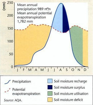
This interaction between run-off, evapo-transpiration and storage is in constant change throughout the year and depends on both the characteristics of the physical environment and climate. The graph to the left shows the water budget for a town in Ghana and shows two distinct seasons. A dry season from November to March and an increasingly wet season from April to October. During the dry season there is a soil moisture deficit, caused by evapo-transpiration exceeding precipitation. Between July and September precipitation exceeds potential evapo-transpiration leading to soil moisture recharge, In September, there is soil moisture surplus. At this point the field capacity (the maximum amount of moisture that soil can retain) is reached. This will lead to changes in storage and increased throughflow and ground water flow. This same period shows a dip in potential evapotranspiration. This can be explained by increased cloud cover blocking the sun's energy.
Drainage Basin Transfers
In the diagram below the drainage basin is illustrated as an open system. Its input is precipitation in the form of rain or snow and its outputs can be seen as evapotranspiration and the river flow itself. Remember that the mouth of the river marks the natural boundary of the drainage basin. The other natural boundary is the atmosphere itself. It is only when precipitation reaches the ground that water enters the drainage basin. As you can see in the diagram, there are many transfers and at each layer, be it on the surface or underground there is storage. Precipitation is stored on the surface in snow. This may be for just one season or it may be for several thousand years in the form of glacial ice. Likewise, water can be stored over varying timescales within vegetation, soil or rock. This may be over vast time scales. The transfer of water through the Great Artesian Basin of Australia is thought to take 2 million years.
Within the drainage basin there are also multiple feedback loops. Water might rise to the surface through springs due to difference in rock and permeability or as a result of capillary rise. Humans extract water from artesian basins through bores, which pull water to the surface as open springs or more controlled bores. In many places precipitation fails to transfer as run-off. Precipitation is intercepted by vegetation and stored, then transpired back into the atmosphere. In hot and humid conditions, strong thermals develop, which may then repeat the process. This is particularly evident in tropical climates and characterise the daily weather patterns of some equatorial regions. This daily pattern of rainfall, interception and transpiration provide the world with some of its richest and most biodiverse physical environments and most important water catchments that feed some of the world's largest river systems.
The balance of water in the drainage basin can be seen in its water budget. The water budget is calculated through the formula,
P =Q +E - ±S.
P - Precipitation
Q - Surface run-off
E - Evapo-transpiration
±S - Change in storage. (in soil or bedrock)
This interaction between run-off, evapo-transpiration and storage is in constant change throughout the year and depends on both the characteristics of the physical environment and climate. The graph to the left shows the water budget for a town in Ghana and shows two distinct seasons. A dry season from November to March and an increasingly wet season from April to October. During the dry season there is a soil moisture deficit, caused by evapo-transpiration exceeding precipitation. Between July and September precipitation exceeds potential evapo-transpiration leading to soil moisture recharge, In September, there is soil moisture surplus. At this point the field capacity (the maximum amount of moisture that soil can retain) is reached. This will lead to changes in storage and increased throughflow and ground water flow. This same period shows a dip in potential evapotranspiration. This can be explained by increased cloud cover blocking the sun's energy.
Drainage Basin Transfers
In the diagram below the drainage basin is illustrated as an open system. Its input is precipitation in the form of rain or snow and its outputs can be seen as evapotranspiration and the river flow itself. Remember that the mouth of the river marks the natural boundary of the drainage basin. The other natural boundary is the atmosphere itself. It is only when precipitation reaches the ground that water enters the drainage basin. As you can see in the diagram, there are many transfers and at each layer, be it on the surface or underground there is storage. Precipitation is stored on the surface in snow. This may be for just one season or it may be for several thousand years in the form of glacial ice. Likewise, water can be stored over varying timescales within vegetation, soil or rock. This may be over vast time scales. The transfer of water through the Great Artesian Basin of Australia is thought to take 2 million years.
Within the drainage basin there are also multiple feedback loops. Water might rise to the surface through springs due to difference in rock and permeability or as a result of capillary rise. Humans extract water from artesian basins through bores, which pull water to the surface as open springs or more controlled bores. In many places precipitation fails to transfer as run-off. Precipitation is intercepted by vegetation and stored, then transpired back into the atmosphere. In hot and humid conditions, strong thermals develop, which may then repeat the process. This is particularly evident in tropical climates and characterise the daily weather patterns of some equatorial regions. This daily pattern of rainfall, interception and transpiration provide the world with some of its richest and most biodiverse physical environments and most important water catchments that feed some of the world's largest river systems.


Hydrographs
River hydrographs show how a river responds to precipitation events within its drainage basin. The hydrograph shows changes in discharge over time. Discharge is defined as the amount of water passing a given point at a given time. It's measured in cubic meters per second and can be calculated from field work data by multiplying cross-sectional area by average velocity. It is mainly collected from gauging sites located at different sites along the course of the river. These gauge sites feed data into one central data base and is managed by a state's environmental agency. The hydrograph is important for feeding in data on the potenital magnitude and frequency of floods. They are therefore a vital means to managing rivers and drainage basins.
In this hydrograph we can see that discharge increases rapidly due to a period of extended rainfall. Hydrologists are most interested in the increase in discharge and the the lag time, which is the length of time separating peak rainfall from peak discharge. Point W on the graph marks the peak rainfall. At this moment, precipitation has not entered the river. After this point in time surface run-off will input water into the river. At point X surface run-off and discharge are increasing rapidly. At point Y discharge is in decline. Surface run-off is still feeding water into the river but it has also passed its peak. At point Z, there are no longer surface run-off inputs and throughflow and ground flow are both in decline. The discharge of the river is almost back to its minimum base flow.
Comparing Hydrographs
Rivers that have a rapid rise in discharge over a short period of time are said to have flash responses and produce a 'Peaky' graph. This is because water is mainly entering the river via surface run-off. Other rivers will have a more benign response to the same rainfall event. Their discharge will not rise so high and the lag time will be extended over a longer period of time. The graph will be much flatter. This is because more water is entering the river via throughflow and groundwater flow and less via surface-run-off. This has the effect of spreading out the flow over an extended period of time; hence the graph is flatter. The reasons for this can be explained by the characteristics of the drainage basin itself.

Changes in the water cycle over time
Natural changes
The inputs, transfers, flows, stores and outputs of the water cycle change over time for a variety of reasons. Some may be natural but others are anthropogenic (human-factors). Let's take a look at these natural and human-related factors.
Natural changes over time affecting water cyclesStorm events
These lead to an increase in both channel flow and surface runoff. Depending upon the drainage basin, flood events can occur.
Seasonal changes
Seasons with high levels of precipitation lead to increased surface runoff and channel flow. In contrast, drier seasons will lead to reduced river discharge and no runoff. In mountainous regions, increased channel flow and runoff can occur due to ice melt. Countries to the south of the Himalayas will face flooding during this time but also will utilise the extra water for agricultural and domestic use.
Ecosystem changes
Plant successions may change the dominant type of vegetation in an area. If vegetation dies off due to natural events there will be less absorption of water by plant roots, and less transpiration – which may reduce precipitation.
Human changes over time affecting water cyclesClimate change
Increasing global temperature is leading to a reduction in size of mountain glaciers and therefore future dependency on this water will become more of an issue as this input declines after a period of increased discharge. Potential drought conditions and associated economic and social impacts will be likely consequences.
Farming practices
Particularly in hotter climates, farming can have a significant effect on the water cycle. Irrigation for plants can lower channel levels in rivers together with groundwater levels if wells are the source for the irrigation.
Deforestation
Removing vegetation for agriculture, urbanisation or – most frequently in many rural developing countries – for fuel supply, an important water store and water-transfer capacity is lost. Soil moisture reduces, transpiration declines and micro-climates give less precipitation, leading to local river systems drying up.
Land use change
Change from natural landscape to urbanised landscape increases impermeable surfaces. This leads to an increase in runoff and a reduction in infiltration. Cities create drainage systems to take water quickly away from the urban environment. However, this can lead to flooding as river levels then receive this water too quickly in a large amount.
Water abstraction
Growth of global population and in particular in countries where climates are drier has resulted in increased water demand. Where precipitation levels are low, an alternative supply is ground water. This supply of water in porous rocks underground is known as an aquifer. Excessive abstraction of this water, where it is taken too quickly and does not recharge naturally, is unsustainable and can lead to groundwater stores being depleted.
River water is also used for water supplies for both domestic and industrial uses and that can affect river levels. In conjunction with limited groundwater reaching the river, the river can ultimately dry up.
Water cycle stores from the met office
Met link - additional reading
Flash card summary of water processes
