Characteristics and formation of landforms resulting from deposition
For the exam, you will need to know about the characteristics and formation of the following landforms resulting from deposition:
1. Beaches
2. Sand Dunes
3. Spits
4. Bars
1. Beaches
2. Sand Dunes
3. Spits
4. Bars
1. Beaches
A beach is the zone of deposited material that extends from the low water line to the limit of storm waves. The beach or shore can be divided in the foreshore and the backshore. Beaches have different characteristics: Some are straight and others in bays are likely to be curved.
What do beaches look like on a map?
|
How are beaches formed?
- Steeply sloping beaches are formed by constructive waves that swash more material up the beach than they backwash away, building up a steep beach gradient.
- Gently sloping beaches form due to strong destructive waves that backwash more material away from the beach than they swash up the beach.
- The material found on a beach (i.e. sand or shingle) depends on the geology of the area and wave energy.
- Sandy beaches are often found in sheltered bays, where they are called bay head beaches. When waves enter these bays, they tend to mirror the shape of the coast. This is called wave refraction. This happens because waves enter shallower water. Wave refraction causes the waves to spread out and reduce the wave energy in the bay, which is why deposition happens here.
2. Sand Dunes
A sand dune is a coastal sand hill above the high tide mark, shaped by wind action, covered with grasses and shrubs.
How do sand dunes form?
- Sand is blown inland from the beach by prevailing wind.
- Sand is trapped at the back of the beach by obstacles.
- Plants start to grow on mounds of sand.
- Over time the mounds get bigger. These are known as sand dunes.
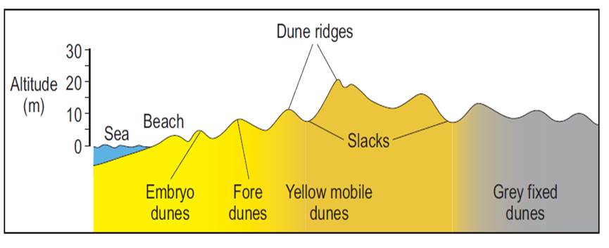
Stage 1: Sand is blown inland. The sand may become trapped by obstacles (seaweed, rock, driftwood) at the back of the beach creating small mounds of sand known as embryo dunes. Only very hardy plants are able to grow here e.g. marram grass. These plants are called pioneers.
Stage 2: The dunes continue to grow in height as more sand is added. When the dunes grow enough so they are out of reach of all but the highest storm tides they are known as foredunes and they are yellow in colour.
Stage 3: As more and more plants colonise the area they begin to add organic matter to the soil. This organic matter is known as humus and it gives the soil more of a grey colour. These dunes can now reach heights in excess of 20 metres.
Stage 4: As conditions for plants improve, the dunes become fixed. Less tolerant species of plant begin to grow here such as mosses and flowering plants.
Stage 5: In places dune slacks develop. These are depressions within the dunes. Conditions are often damp. Rushes, reeds and mosses can be found here.
Stage 6: Behind the yellow and grey dunes, the supply of beach sand is gradually cut off, giving smaller dune features. Heather and gorse are the main plants. Towards the rear of the dune, woodland may occur with trees such as pine and birch. This is know as climatic climax.
3. Spits
A spit is a depositional landform formed when a finger of sediment extends from the shore out to sea, often at a river mouth. It usually has a curved end because of opposing winds and currents.

|
What do spits look like on a map?
|
How do spits form?
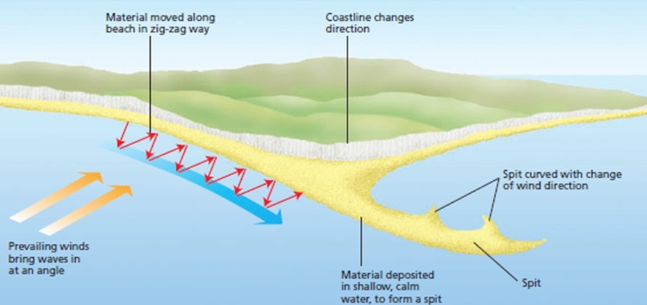
- As sediment is transported along the coast by longshore drift (the zigzag movement of sediment along the beach due to swash and backwash), it becomes deposited at a point where the coastline changes direction or where a river mouth occurs.
- As more and more sediment is deposited, the feature extends into the sea.
- Away from the coast, the end of the spit is often affected by the wind direction and the waves approaching from different directions and the spit becomes curved.
- Over time, the sediment builds up to form new land and a spit is formed.
- It soon becomes colonised by plants.
- On the landward sheltered side of the spit where water is calm, mudflats and salt marshes form.
A diagram showing spit formation
Revision web-links and videos:
4. Bars
Occasionally longshore drift may cause a spit to grow right across a bay, trapping a freshwater lake or lagoon behind it. This feature is called a bar. An example can be seen at Slapton Ley in Devon or Chesil Beach in Dorset.

|

|
Revision weblinks:
www.bbc.co.uk/education/clips/z6yw2hv
www.bbc.co.uk/education/clips/z6yw2hv
