3.1.3.3 Coastal landscape development
- This content must include study of a variety of landscapes from beyond the United Kingdom (UK) but may also include UK examples.
- Origin and development of landforms and landscapes of coastal erosion: cliffs and wave cut platforms, cliff profile features including caves, arches and stacks; factors and processes in their development.
- Origin and development of landforms and landscapes of coastal deposition. Beaches, simple and compound spits, tombolos, offshore bars, barrier beaches and islands and sand dunes; factors and processes in their development. Estuarine mudflat/saltmarsh environments and associated landscapes; factors and processes in their development.
- Eustatic, isostatic and tectonic sea level change: major changes in sea level in the last 10,000 years. Coastlines of emergence and submergence. Origin and development of associated landforms: raised beaches, marine platforms; rias, fjords, Dalmatian coasts.
- Recent and predicted climatic change and potential impact on coasts.
- The relationship between process, time, landforms and landscapes in coastal settings.
Landforms of erosion
Headlands and bays

- Headland and bays form along the coastline where there are alternating layers of hard and soft rock.
- A process called erosion causes the soft rock to erode away faster than hard rock because it is significantly less resistant. Also, soft rock can become top heavier easier in mass movement, causing it to slump.
- Consequently, this creates a bay, in between two headlands. Sediment from long-shore drift and from constructive waves is deposited in the bay, creating a beach area.
- Overtime, hard rock is eroded away by erosional processes such as abrasion and hydraulic action. Hydraulic action is when the sheer weight and force of waves hit the cliff face and compress water and air into cracks, breaking parts off. Rock fragments from hydraulic action are picked up by waves and are hurled at the cliff face, eroding it away. This is called abrasion.
- However. while the headlands are being eroded away, bays are being sheltered from the wave action due to wave refraction.
- This happens until the headland and bay are level and the process can start again.
- An example of a headland and bay in the UK includes Slapton Sands bay in Devon, located in south-west England.
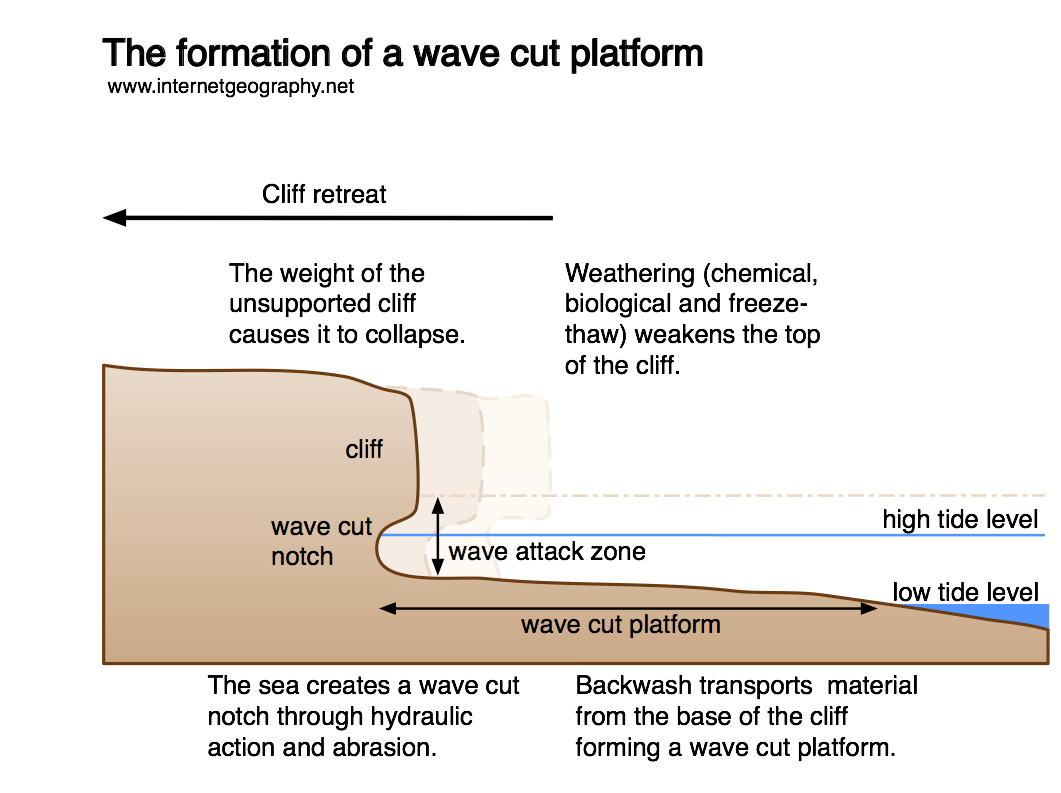
Wave cut platform and cliff retreat
- Wave cut platforms along the coast as a consequence of cliff erosion.
- For this to happen, there must be a concentration of erosion between low and high tide, since here rocks can be hurled at the cliff face, eroding it away like sandpaper. This is called abrasion.
- Eventually, a wave cut notch id formed, creating an overhang because it has been undercut by erosion.
- This happens until the cliff becomes very unstable and collapses under gravity.
- Overtime, the cliff retreats, leaving behind a wave cut platform because no erosion can take place below the tide. therefore, a rock platform is left behind, which can only be seen as low tide. This process starts again.
- An example of a wave cut platform includes Southern Down, located in Wales, United Kingdom.
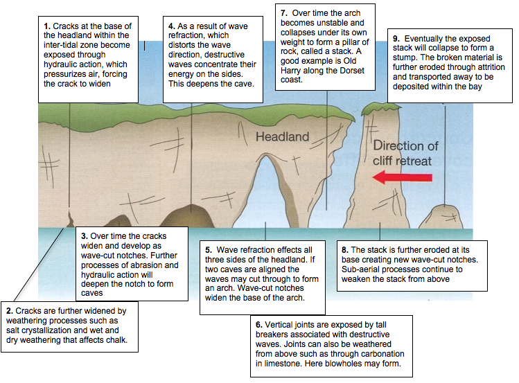
Erosion of Headland- crack, cave, arch, stack, stump and blowholes
- Crack, cave, arch, stack, stump and blowholes form along a headland due to a process called erosion.
- It begins with a crack in the headland, which is often caused by hydraulic action. This type of erosion is when the sheer weight and force of waves hit the cliff face and compress water and air into cracks. Consequently, the build-up of pressure can lead to parts of the cliff rock breaking off.
- Then, this crack erodes into a bigger crack, until the point where it becomes a cave.
- This cave is further eroded until it becomes an arch due to abrasion. This process is when rocks are hurled at the cliff rock and consequently, erode it away like sandpaper.
- The arch is eroded until the point where it is too weak to support itself and collapses under gravity, leaving behind a stack.
- This stack is left standing alone away from the coast, until it is weathered down into a stump.
- An example of erosion on a headland is Old Harry, in Dorset United kingdom. These erosional land forms are evident all along this coastline. However, it does not feature a blowhole, which is formed as a consequence of vertical erosion underneath a cave and weathering on top.
Coastal Deposition
Beaches
On a beach, many landforms are created and formed. These may be contrastingly different or similar, depending on the location of where the landform is found.
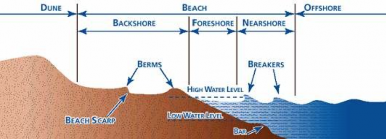
Storm beach - at the back of the beach, near the cliff, you will find a storm beach. Storm beaches are formed during the event of the storm as the waves presently have a strong swash, therefore they have enough energy to pick up large material and carry it to the back of the beach. This creates a storm beach or ridge-like relief of shingle material.
Berms - In front of a storm beach, you are likely to find berms. These are small ridges that develop at mean high tide, resulting in the deposition of shingle in front of the previous landform. This is due to swash from the oncoming waves. The shingle is also smaller that on storm beaches. Berms also represent the positional change of the high tide and low tide and can usually be found on any coastline such as the berms in south west Italy, located in the gulf of Salerno.
Cusps - This is when material changes from shingle to sand; you are likely to find cusps landforms. It is here that the gradient of the beach changes. Cusps are semi-circular depressions and so are very different in shape, compared to other beach landforms. They are smaller than other landforms and are usually temporary because they are formed by waves reaching the same point. The sides of the cusp channel the incoming swash and the centre of the depression helps produce a stronger backwash because it is easier for material to be dragged away.
Ridges and runnels - Runnels are formed at the front of beaches and are left behind when the tide goes out. They are widespread across the beach and are in a runnel/ripple depression. They run parallel to the shore and are formed at particularly shallow and sandy beaches.
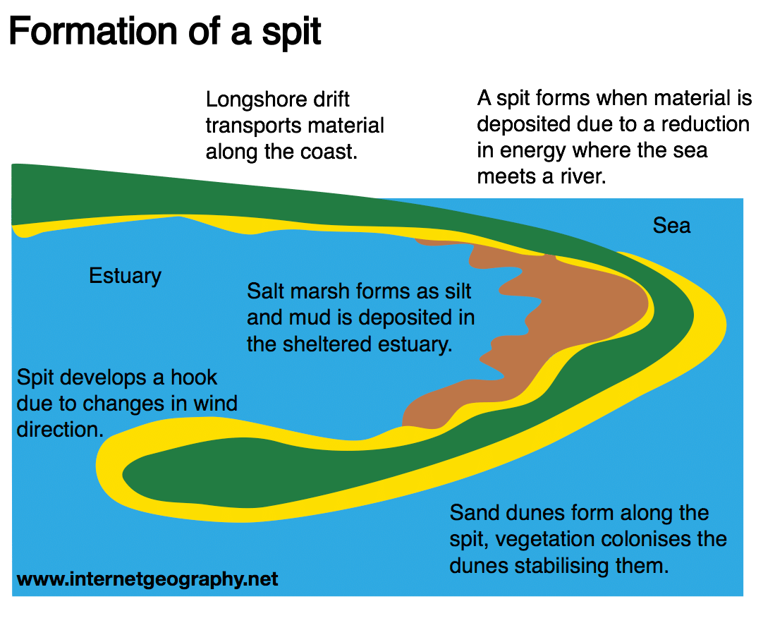
Spits (simple and compound), bar, tombolo and offshore bars.
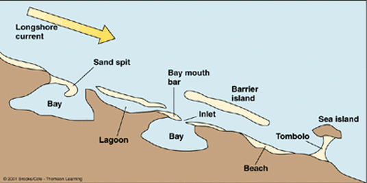
Spit: the deposition of material transported along a coast by longshore drift (littoral movement) at a break in coast orientation and where the dominant current slows and weakens to produce an extended finger of depositional material, often with a recurved end.
Compound spits exhibit a number of recurved ‘spurs’ along their length as each recurvature represents a ‘break in coast orientation’ and the development of a new extension of the main spit under conditions of consistent longshore drift.
Bar: a continuation of a spit to join on to the coast across a bay. Usually where there is a break in coastline with longshore drift operating but without an intervening river current to disrupt continuous deposition.
Tombolo: where a spit happens to extend and join to an island, linking it to the mainland by a narrow beach of deposited material.
Offshore bar and barrier islands: characteristic of shores with a large influx of sediment, often from major rivers and currents which deposit and build accumulations of material into long, low mounds of sediment parallel to the coast. Offshore bars are largely submarine features while barrier islands are usually above high tide and contain sand dune formations.
|
|
Sand Dunes
Introduction
Depositional features at the coast may be temporary (beach cusps) or longer-lasting (spits), but others are transformational; they undergo change from one form to another over relative short periods of time measured in decades.
Environmental habitats at the coast alter as a result of plant succession, which cause changes to micro-climate features and soil states, and which – in turn – create more favourable conditions for new plant species to colonise a section of shoreline.
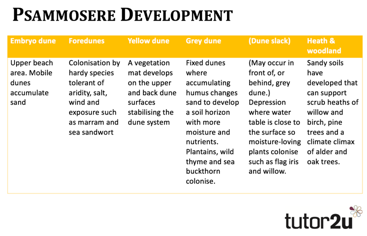
Sand dune development
Sand dunes are more likely to develop behind an active beach zone where:
Sand dunes may grow in front and behind initiating dunes. Over time a succession of plants colonises a dune system which also gives a longitudinal profile from upper beach extending inland. As new sand dunes evolve towards heath and pine woodland inland, the ecological succession is called a psammosere.
Depositional features at the coast may be temporary (beach cusps) or longer-lasting (spits), but others are transformational; they undergo change from one form to another over relative short periods of time measured in decades.
Environmental habitats at the coast alter as a result of plant succession, which cause changes to micro-climate features and soil states, and which – in turn – create more favourable conditions for new plant species to colonise a section of shoreline.
Sand dune development
Sand dunes are more likely to develop behind an active beach zone where:
- The gradient of the ground inland adjacent to a beach is relatively flat.
- Strong onshore winds provide the energy input to move sand inland from a beach.
- A beach is composed of fine sand particles rather than shingle, pebbles or rocks.
- A large area of beach is exposed at low tide.
Sand dunes may grow in front and behind initiating dunes. Over time a succession of plants colonises a dune system which also gives a longitudinal profile from upper beach extending inland. As new sand dunes evolve towards heath and pine woodland inland, the ecological succession is called a psammosere.
Estuaries
An estuary is an area where a freshwater river or stream meets the ocean. In estuaries, the salty ocean mixes with a freshwater river, resulting in brackish water. Brackish water is somewhat salty, but not as salty as the ocean.
Water continually circulates into and out of an estuary. Tides create the largest flow of saltwater, while river mouths create the largest flow of freshwater.
When dense, salty seawater flows into an estuary, it has an estuarine current. High tides can create estuarine currents. Saltwater is heavier than freshwater, so estuarine currents sink and move near the bottom of the estuary.
When less-dense freshwater from a river flows into the estuary, it has an anti-estuarine current. Anti-estuarine currents are strongest near the surface of the water. Heated by the sun, anti-estuarine currents are much warmer than estuarine currents.
In estuaries, water level and salinity rise and fall with the tides. These features also rise and fall with the seasons. During the rainy season, rivers may flood the estuary with freshwater. During the dry season, the outflow from rivers may slow to a trickle. The estuary shrinks, and becomes much more saline.
During a storm season, storm surges and other ocean waves may flood the estuary with saltwater. Most estuaries, however, are protected from the ocean's full force. Geographical features such as reefs, islands, mud, and sand act as barriers from ocean waves and wind.
The picture below show an estuary with a salt marsh in the foreground of the picture.
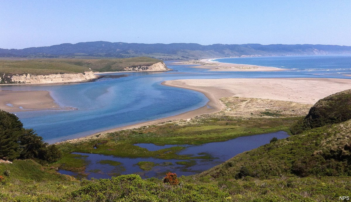
Salt marshes
Salt marshes often occur in sheltered river estuaries or behind spits. Vegetation develops in the intertidal mudflats found in these areas. An example of this is behind Spurn Point in the Humber Estuary.
